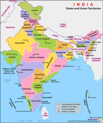
Map of India Political

₹125.00
availability: In Stock

Description

  1. Administrative Divisions: States and union territories demarcated with clear boundaries.
  2. Capital Cities: Capitals of states and union territories are prominently marked.
  3. Major Cities: Important urban centers like Mumbai, Delhi, Kolkata, Chennai, and Bengaluru are highlighted.
  4. Transportation Networks: Highways, railways, airports, and seaports are depicted for connectivity.
  5. Geographical Features: Rivers, mountains, coastlines, and other natural landmarks are outlined.
  6. International Borders: Boundaries with neighboring countries like Pakistan, China, Nepal, Bhutan, Bangladesh, and Myanmar are shown.
  7. Cultural Diversity: Reflects India's diverse linguistic, religious, and ethnic groups.
  8. Reference Tool: Used by officials, researchers, educators, and travelers for information and understanding India's political and geographical landscape.


Reviews

No reviews have been written for this product.

Write your own review

Opps

Sorry, it looks like some products are not available in selected quantity.

OK